














EUDR compliance · sourcing & first mile

Every plot mapped. Every shipment EUDR ready.

TRST01Chain digitises farmer onboarding, plot polygons and recording transactions, generating GeoJSON sets & DDS for every shipment.
Trusted across supply chains of all sizes
TRST01, your trusted partner for EUDR compliance
200+
Organisations across 10+ countries rely on TRST01Chain to stay EUDR-ready.
Technology & implementation partner to the Rubber Board of India for nationwide EUDR implementation.
The regulation, in plain terms
What the EUDR asks every operator to prove.
To place a regulated commodity on the EU market, you must show it did not come from land deforested after 31 December 2020, that it was produced legally, and that you can trace it to the exact plot, then file a Due Diligence Statement. TRST01Chain produces every one of these, from the data you capture in the field.
Geolocation to polygon level
Precise plot boundaries, not just a GPS point, for every production area.
Deforestation-free after 2020
Satellite evidence that the plot was not cleared of forest after the cut-off date.
Legal production
Proof the commodity was produced in line with the laws of the country of origin.
Due Diligence Statement
A DDS filed to the EU Information System, backed by traceable evidence.
 What you get
Everything EUDR requires, generated from field data.
TRST01Chain is built for one outcome: an EUDR submission that holds up, shipment after shipment.
Map to polygon level, three ways
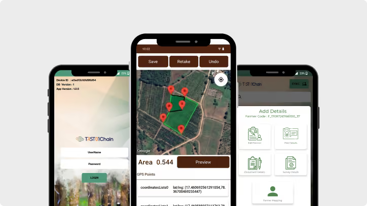
Capture accurate plot geometry by KML upload, GPS walk, or tapping the satellite map, tagged to each farmer with digital consent.
Outcome: geolocation that passes checks
Screen deforestation automatically
Every polygon is checked against the EU deforestation layer since Dec 2020, returning a plot-level verdict and farmer risk score.
Outcome: risk caught before you buy
Keep traceability unbroken
Every transaction is recorded down the chain, with deforestation-free lots segregated, so origin survives to the gate.
Outcome: audit-ready chain of custody
Generate the DDS & GeoJSON in a click
The Due Diligence Statement, Traceability Certificate and GeoJSON are produced from your data, ready for the EU Information System.
Outcome: weeks of prep down to days
Scale to thousands of farmers
Dealers' own field agents onboard farmers on a simple app; our backend validates the data. Coverage grows in a season, not years.
Outcome: whole supply base, digitised
Protect EU market access
Give buyers the compliant documents they need, clear shipments on time, and command a premium for proven material.
Outcome: shipments that clear, not stall
how it works
Your EUDR workflow, end to end
Four steps that map to exactly what the regulation asks for. Tap a step to explore it.
 Our tech stack
One tech stack that simplifies each part of EUDR
Two mobile apps and one web portal cover onboarding, transactions and submission.
Field Executive App
Farmer KYC, consent, legality and polygon mapping in the field. Offline-first design and multilingual, so it works anywhere.
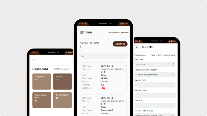
IntelliTrack App
Every dealer and agent records each transaction and batches lots. Offline-first and multilingual, keeping the chain intact.
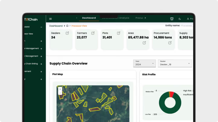
Processor's Web Portal
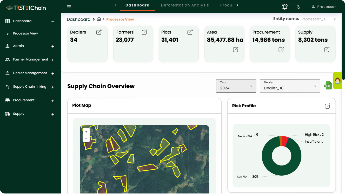
The command centre: deforestation dashboard, gate GRNs, and one-click DDS, certificate and GeoJSON.
The heart of EUDR
Every plot, checked against the forest as it stood in 2020.
When a polygon is captured, our backend runs deforestation analysis with the EU deforestation layer embedded and returns a clear verdict for each plot.
Detailed analysis for every individual plot
Change detected since 31 December 2020
Automatic compliant / at-risk flag, plus a farmer risk score
Who uses it
Built for everyone who moves the material
Processor / Exporter
Runs the web portal, sees the full chain, and issues certificates and the DDS.
Dealers & sub-dealers
Each gets an IntelliTrack login and records every purchase along the chain.
Field agents
Dealers' or the procurement team's agents onboard farmers and map plots.
Farmers
No app to install. Their KYC, consent and plot are captured for them.
Who uses it
Runs the web portal, sees the full chain, and issues certificates and the DDS.
Dealers & sub-dealers
Each gets an IntelliTrack login and records every purchase along the chain.
Field agents
Dealers' or the procurement team's agents onboard farmers and map plots.
Farmers
No app to install. Their KYC, consent and plot are captured for them.
Free guides

Get EUDR-ready, start with the basics

Practical, plain-English guides from the team behind India's largest EUDR rollout.
PDF GUide
The EU Operator's Guide
 to EUDR Compliance
Complete the form to access your free guide.
Thank you! Your submission has been received!
Oops! Something went wrong while submitting the form.
Download for free
PDF GUide
The Manufacturer's Guide
 to EUDR Compliance
Complete the form to access your free guide.
Thank you! Your submission has been received!
Oops! Something went wrong while submitting the form.
Download for free
PDF GUide
From Regulation to Readiness
: A Beginers Guide to EUDR
Complete the form to access your free guide.
Thank you! Your submission has been received!
Oops! Something went wrong while submitting the form.
Download for free
PDF GUide
The Upstream Guide to
 EUDR Compliance
Complete the form to access your free guide.
Thank you! Your submission has been received!
Oops! Something went wrong while submitting the form.
Download for free
FAQ
EUDR & TRST01Chain FAQ
Who is TRST01Chain for?

Upstream processors and exporters who procure raw material from farmers, directly or through dealers and agents, and need to make that sourcing EUDR-compliant, from the first plot to a submission-ready Due Diligence Statement (DDS).

Are GPS coordinates enough, or do we need polygons for every farmer?

For production areas above the size threshold (generally plots over 4 hectares) a single GPS point is not enough; EUDR expects a polygon tracing the plot boundary. TRST01Chain captures polygons by default in the Field Executive App, three ways: KML upload, walking the boundary, or tapping the satellite map.

What data do you collect from each farmer, and do farmers need an app?

For every farmer: KYC and consent, land-ownership or legality evidence, crop and plot details, and the plot polygon, captured in one onboarding visit. Farmers install nothing. Dealers' or the procurement team's field agents capture it for them using the Field Executive App, which is offline-first and multilingual.

How do you keep traceability across a complex, multi-tier chain?

Every player between farmer and processor, dealers, sub-dealers and agents, records each purchase in the IntelliTrack app under their own login. Deforestation-free lots stay segregated (EUDR does not allow mass-balance mixing), and batches always resolve back to the contributing farmers and plots, so aggregation never breaks the chain.

How is deforestation analysis done?

Once a polygon is captured, our backend runs that plot against the EU deforestation layer using multi-constellation satellite imagery, detecting any forest change since 31 December 2020. Each plot gets its own compliant or at-risk verdict plus a farmer risk score, and legality is verified against local rules alongside it.

Are results machine-only, and what happens to an at-risk plot?

Results are checked, not left to automation alone: the TRST01 backend team validates the field data and reviews the analysis, which helps catch false positives. An at-risk plot is flagged for mitigation, so you can investigate or keep its produce out of EU-bound batches, and out of the DDS, before you commit to buy or ship.

What documents do you generate for the EU?

At shipment, the Web Portal generates a QR-based Traceability Certificate, the Due Diligence Statement with the analysis report, and the GeoJSON plot-geometry file, all from data you already captured and ready for the EU Information System (EUIS). Records are kept searchable and audit-ready for the EUDR's 5-year retention period.

We hold origin data on paper today. How do we start?

That is the normal starting point. Begin free with the EUDR Polygon Checker to validate a sample of your plot data, then roll out field-agent onboarding across your sourcing areas and stand up the Web Portal. Existing plot boundaries can be brought in as KML files; everything else is captured going forward.